Table of Contents
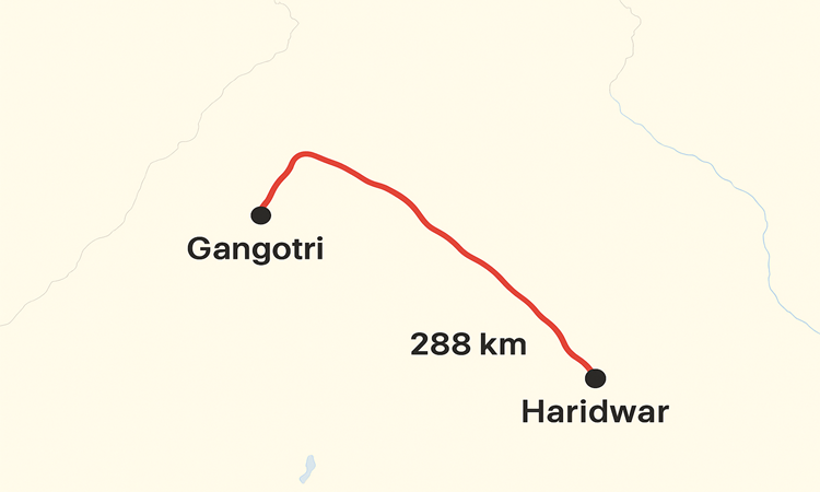
The journey from Haridwar, the ancient gateway to the Himalayas, to Gangotri, the revered source of the holy River Ganga, is more than just a road trip; it is a profound spiritual pilgrimage known as the Gangotri Yatra. This segment forms a crucial part of the famous Char Dham Yatra in Uttarakhand, drawing millions of devotees, trekkers, and nature enthusiasts every year. Understanding the logistics, particularly the Haridwar to Gangotri distance, is the first and most vital step in planning this memorable Himalayan odyssey.
This comprehensive guide delves deep into the essential elements of this route, offering practical advice, detailing the picturesque stops, and outlining what pilgrims can expect from the road conditions and travel times along National Highway 34 (NH 34).
The Core Fact: Haridwar to Gangotri Distance and Estimated Travel Time
The Haridwar to Gangotri distance by road generally spans between 270 kilometers (km) and 290 km, with the commonly cited average route covering approximately 288 km. It is essential to note that while this distance may seem manageable on a map, the actual travel time is significantly affected by the mountainous terrain, winding roads, and traffic flow, especially during peak Yatra season.
The estimated travel time for this journey ranges from 8 to 12 hours of continuous driving. However, attempting to cover the entire distance in a single day is strongly discouraged due to the challenging hill roads. The journey is best undertaken over two days, allowing for a comfortable overnight halt, usually in the spiritual hub of Uttarkashi, which provides better acclimatization and rest.
The route officially follows the alignment of the National Highway 34 (NH 34) for most of its length. This highway transitions from the relatively flat roads of the plains to the steep, winding, and often narrow mountain roads of the Garhwal Himalayas. The journey can be logically broken down into two distinct phases, each offering unique challenges and breathtaking vistas.
Phase I: The Transition from Plains to Hills (Haridwar to Uttarkashi)
The first half of the pilgrimage takes travelers from the plains of Haridwar into the heart of the Garhwal Himalayas, culminating at the district headquarters of Uttarkashi. This leg is crucial for both mental and physical preparation.
Haridwar to Rishikesh (Approx. 25 km)
The journey begins in Haridwar, where pilgrims traditionally take a holy dip (snan) at Har ki Pauri before embarking on the Yatra. The initial drive to Rishikesh is quick and smooth, taking roughly 45 minutes to an hour. Rishikesh, the “Yoga Capital of the World,” serves as the last major city hub before the climb truly begins. Many travelers prefer starting the pilgrimage from Rishikesh, as Haridwar and Rishikesh are well-connected by train and air (via Jolly Grant Airport, Dehradun).
Rishikesh to Tehri Dam/Chamba (Approx. 70-80 km)
From Rishikesh, the route winds through forested areas and along the Ganga/Bhagirathi River. This stretch requires careful driving as the roads begin their ascent into the hills. Key stops or junctions include Narendra Nagar, where the path diverges, or Chamba, which offers stunning panoramic views. A significant landmark on this route is the impressive Tehri Dam reservoir, a massive engineering feat that has created one of Asia’s largest man-made lakes. The massive expanse of the reservoir offers a striking visual contrast to the surrounding Himalayan slopes.
Tehri to Uttarkashi (Approx. 100 km)
Continuing on NH 34, the journey proceeds to Uttarkashi, often referred to as the gateway to both Gangotri and Yamunotri. Uttarkashi is the traditional and recommended overnight stop for the journey. Located at an elevation of 1,158 meters (3,800 feet), it is a large town nestled on the banks of the Bhagirathi River.
Uttarkashi: The Ideal Halting Point Uttarkashi is spiritually significant in its own right, housing the ancient Kashi Vishwanath Temple, similar in sanctity to the one in Varanasi. Stopping here serves three main purposes:
Rest and Refuel: It is the last major town with extensive facilities, fuel stations, and comfortable accommodation options.
Acclimatization: Although not extremely high, spending a night here helps the body begin to adjust to the increasing altitude, which is vital before proceeding to the 3,415-meter elevation of Gangotri.
Logistics: All onward taxis and buses to Gangotri depart early in the morning from Uttarkashi.
This entire first phase, covering roughly 190 km to 200 km, takes about 6 to 8 hours of driving time and sets the stage for the dramatic scenery of the upper Himalayas.
Phase II: Into the High Himalayas (Uttarkashi to Gangotri)
The second, shorter but more scenic phase covers the remaining 90 km to 100 km of the Haridwar to Gangotri distance. This section of the route is entirely within the high mountainous region, characterized by narrow, winding roads, steep gradients, and incredible proximity to the towering Garhwal peaks.
Key Stopovers: Gangnani and Harsil
The road from Uttarkashi to Gangotri is arguably one of the most visually stunning stretches of the Yatra.
Gangnani: The Hot Spring Oasis
Located approximately 45 km from Uttarkashi, Gangnani is a small village known for its natural thermal springs (hot water kunds). Taking a dip in these sulfurous waters is a revered ritual for pilgrims, believed to cleanse the body before reaching the final, sacred destination. It offers a refreshing break before the altitude increases significantly.
Harsil: The Mini-Switzerland of India
Roughly 25 km before Gangotri lies the exquisite Harsil Valley. Often called the “Mini-Switzerland of India,” Harsil is famed for its stunning natural beauty, apple orchards, and picturesque setting on the banks of the Bhagirathi. This quaint village offers some of the most beautiful views of the Himalayan forests and snow-capped peaks. Nearby Mukhba village is significant as it is the winter abode of Goddess Ganga when the Gangotri temple gates are closed due to heavy snow. Harsil is an excellent spot for photographers and is often considered a spiritual reward for completing the demanding drive.
The Final Approach to Gangotri
From Harsil, the final 25 km drive is marked by high-altitude vegetation and dramatic landscapes. The roads, while motorable, are particularly narrow and require the utmost caution. Upon arrival at Gangotri (elevation 3,415 m or 11,200 ft), vehicles can generally only go up to a specific parking area. The final destination, the Gangotri Temple, dedicated to Goddess Ganga, is reached after a short walk.
It is here that the Bhagirathi River (which merges downstream to form the Ganga) bursts forth. The actual source, the Gaumukh Glacier, lies approximately 19 km further, requiring a challenging high-altitude trek and a necessary permit. The road journey concludes at Gangotri, marking the physical completion of the pilgrimage from Haridwar. This second phase of the journey typically takes 3 to 5 hours of dedicated driving time, depending on road conditions and stoppages.
Logistics: Modes of Transport and Practical Advice
Successfully navigating the Haridwar to Gangotri distance requires careful selection of transport and planning.
1. By Public Bus (Budget-Friendly)
Operator: GMOU (Garhwal Mandal Unian Limited) is the primary government-run transport service.
Availability: Direct buses from Haridwar to Gangotri are less frequent and often require an early start (usually pre-dawn). It is generally easier and more reliable to take a bus to Rishikesh or Uttarkashi first.
Journey Time: The total journey by public bus takes the longest, usually between 10 to 14 hours, including multiple stops, or is broken over two days with an overnight stop in Uttarkashi.
Fare: This is the most economical option, typically costing between INR 500 and INR 1,000 per person for the full one-way trip.
2. By Shared Taxi or Jeep (Semi-Private)
Flexibility: Shared vehicles (like sumos or large taxis) are readily available from Rishikesh and Uttarkashi, offering a faster and slightly more comfortable ride than the bus.
Booking: They operate on a shared basis, filling up with pilgrims before departure. This is a good option if you are a solo traveler or a small group.
Time: Shared vehicles adhere to mountain driving rules and are usually quicker than buses, often completing the Haridwar-Gangotri stretch in 9 to 10 hours if started very early, though breaking the journey in Uttarkashi remains standard practice.
3. By Private Taxi or Cab (Comfort and Convenience)
Optimal Choice: Hiring a private cab or a Tempo Traveller is the most convenient option, as it offers control over the itinerary, stops for sightseeing, and departure times.
Cost: This is the most expensive mode, with one-way fares ranging from INR 7,000 to INR 12,000 or more, depending on the season and vehicle type.
Safety: Ensure the driver is experienced in mountainous terrain and holds the necessary permits for the high-altitude routes.
Driving Your Own Vehicle (The Adventurous Choice)
For those using their own vehicle, a mandatory registration, often known as the Char Dham Trip Card or registration on the Uttarakhand Tourism portal, is required. It is vital to use vehicles that are well-maintained and suitable for steep, winding roads, such as SUVs or robust hatchbacks with good ground clearance.
Road Conditions and the Best Time to Travel
The quality of the road surface along the Haridwar to Gangotri distance can vary dramatically depending on the season and ongoing infrastructure work, such as the Char Dham Pariyojana (which aims to widen and improve the network).
The Ideal Window: Summer and Autumn
The Gangotri Temple, along with the other Char Dhams, remains closed for approximately six months due to heavy snowfall. The doors typically open around the auspicious day of Akshaya Tritiya (late April/early May) and close after Diwali (late October/early November).
Peak Season (May-June): The weather is pleasantly cool, and the roads are generally in the best condition, free of winter snow and monsoon damage. This is the busiest time for the Yatra.
Shoulder Season (September-October): The monsoon has receded, leaving the atmosphere crisp, the mountains lush, and offering the clearest views of the Himalayan peaks. Road closures are minimal, making this an ideal time for a smooth journey.
The Monsoon Challenge (July-August)
Travel during the monsoon season should be approached with extreme caution. Heavy rainfall significantly increases the risk of landslides and road blockages, which can cause delays of several hours or even days. While the administration is quick to clear blockages using heavy machinery, the journey becomes inherently more unpredictable and dangerous. Travelers must stay updated on real-time road status reports before proceeding.
Essential Preparation and Travel Tips
A journey of this magnitude requires careful planning beyond just knowing the Haridwar to Gangotri distance.
Acclimatization and Health
Gangotri sits at a high altitude (3,415 m). Travelers must take precautions against Acute Mountain Sickness (AMS).
Break the Journey: Always plan an overnight halt in Uttarkashi.
Hydration: Drink plenty of water throughout the journey to combat dehydration and altitude effects.
Pace Yourself: Avoid rushing, especially on the final ascent to Gangotri. If you plan to trek to Gaumukh, spend a day resting in Gangotri first.
Packing Essentials
Warm Clothing: Even in summer, temperatures can drop drastically in the evenings and mornings, particularly in Gangotri. Pack thermal wear, gloves, caps, and warm jackets.
Rain Gear: A waterproof jacket and rain covers for luggage are essential, even outside the monsoon months.
Basic Medicines: Carry a personal medical kit, including pain relievers, digestive aids, and medication for cold and cough.
Identity and Registration: Keep your government-issued ID (Aadhaar or Voter ID) and the mandatory Char Dham registration documents (if applicable) handy.
On-Road Safety
Night Driving: Avoid driving between Uttarkashi and Gangotri after sunset. The mountain roads lack guardrails in many places, and visibility drops severely due to mist and hairpin bends.
Fuel and Food: While Uttarkashi has ample facilities, petrol pumps and reliable multi-cuisine restaurants become sparse beyond this point. Ensure your tank is full and carry sufficient snacks and water for the second leg of the journey.
Conclusion: The Spiritual Reward
The drive covering the Haridwar to Gangotri distance, spanning approximately 288 km and navigating challenging Himalayan topography, is undeniably demanding. Yet, the reward is immeasurable. The journey progresses from the bustling spiritual energy of Haridwar to the tranquil, icy source of the Ganga, allowing pilgrims to witness the river in its pristine, nascent form. By prioritizing safety, planning for an overnight rest in Uttarkashi, and respecting the unpredictable nature of the mountains, this odyssey promises to be a deeply moving and unforgettable experience, culminating in the sublime beauty and spiritual purity of Gangotri Dham.
Frequently Asked Questions (FAQs)
1. What is the approximate Haridwar to Gangotri distance by road and the typical travel time?
Ans. The haridwar to gangotri distance by road is approximately 288 kilometers (180 miles) via the main National Highway 34 (NH 34). The actual driving time is highly variable due to mountainous terrain and traffic, but generally ranges from 8 to 12 hours of continuous travel.
2. Is it safe or recommended to complete the entire Haridwar to Gangotri journey in a single day?
Ans. While a full day’s drive (10-12 hours) can cover the distance, it is strongly discouraged. The mountainous section is difficult and winding, leading to severe driver fatigue. It is highly recommended to break the journey and spend the night in Uttarkashi for rest and crucial high-altitude acclimatization.
3. What is the best and safest time of year to undertake the Gangotri Yatra?
Ans. The temple is open from late April/early May (Akshaya Tritiya) until late October/early November (around Diwali). The best times for travel are the pre-monsoon summer months (May and June) and the post-monsoon autumn months (September and October). Monsoons (July-August) bring a high risk of landslides and road closures.
4. What are the key stopovers and major towns along the Haridwar to Gangotri route?
Ans. The main stops on the route are:
- Rishikesh: The initial major town and common starting point.
- Uttarkashi: The mandatory overnight halting point, offering the last major amenities and services.
- Gangnani: Known for its therapeutic hot springs.
- Harsil: A beautiful, scenic valley known for its apple orchards, approximately 25 km before Gangotri.
5. How are the road conditions, especially considering the Char Dham Pariyojana construction?
Ans. The roads (NH 34) are generally motorable and improving under the Char Dham Pariyojana. However, they are narrow, winding, and prone to temporary blockages from landslides or construction work, particularly in the monsoon season. Always hire an experienced mountain driver or check current road status before traveling.
6. What are the best options for transportation from Haridwar to Gangotri?
Ans. The three primary options are:
- Private Taxi/Cab: The most comfortable, fastest, and flexible option (best for multi-day trips).
- Shared Taxi/Jeep: Available primarily from Rishikesh and Uttarkashi, offering a balance of speed and cost for small groups or solo travelers.
- Public Bus (GMOU): The most budget-friendly option, but buses are less frequent and often require breaking the journey into segments.
7. How far is the actual source of the Ganga (Gaumukh Glacier) from Gangotri Temple?
Ans. The Gaumukh Glacier, the geological source of the Bhagirathi River (which becomes the Ganga), is located approximately 19 kilometers (12 miles) from the Gangotri Temple. Reaching Gaumukh requires a challenging high-altitude trek, and a special permit must be obtained from the Forest Department in Uttarkashi or Gangotri.
8. What should I pack concerning the altitude and weather for the trip?
Ans. Even in summer, temperatures can drop to near freezing in Gangotri due to its elevation (3,415 m). Essentials include multiple layers of warm clothing, thermal wear, waterproof jackets, caps, gloves, a basic medical kit, and necessary medication for altitude sickness prevention.
9. Do I need any mandatory permits or registration to travel this route?
Ans. Yes, all pilgrims and vehicles traveling on the Char Dham route are typically required to complete a mandatory digital or offline registration process (often referred to as the Char Dham Yatra Registration) with the Uttarakhand government. This is essential for safety monitoring.
10. What are the altitude concerns for the journey, and how can I prevent Acute Mountain Sickness (AMS)?
Ans. The elevation difference between Haridwar (314 m) and Gangotri (3,415 m) is significant. To prevent AMS, you must: a) Break the journey (stay overnight in Uttarkashi), b) Hydrate constantly, c) Avoid smoking/alcohol, and d) Ascend gradually without overexertion.