The journey to Kedarnath, one of the twelve Jyotirlingas of Lord Shiva, is not merely a physical traverse but a profound spiritual odyssey that draws millions of devotees and trekkers each year. Nestled amidst the majestic Garhwal Himalayas in Uttarakhand, the ancient Kedarnath temple stands as a testament to faith and endurance. The traditional starting point for this revered pilgrimage is Gaurikund, a sacred site believed to be where the Goddess Parvati meditated to win the affection of Lord Shiva. Understanding the Gaurikund to Kedarnath distance is paramount for anyone planning this challenging yet deeply rewarding trek.
The Sacred Path Begins: Gaurikund to Kedarnath
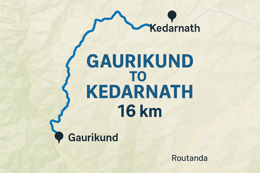
The distance from Gaurikund to Kedarnath by foot is approximately 16 to 18 kilometers, depending on the exact route taken and current trail conditions. This distance, while seemingly modest, covers a significant altitude gain, transforming it into a strenuous yet exhilarating trek. Gaurikund, situated at an elevation of around 1,982 meters (6,502 feet) above sea level, marks the last road head. From here, the only way to reach the Kedarnath temple, perched at an impressive 3,583 meters (11,755 feet), is either by trekking, hiring a pony or doli, or opting for a helicopter service that lands at a short distance from the temple.
The trek is renowned for its breathtaking natural beauty, with panoramic views of snow-capped peaks, lush green valleys, roaring Mandakini River, and cascading waterfalls. However, it is also known for its challenging terrain, which includes steep ascents, rocky paths, and sometimes slippery sections, especially during or after rainfall.
Key Waypoints Along the Trek
The trail from Gaurikund to Kedarnath is well-defined and has seen significant improvements, particularly after the devastating floods of 2013. Several waypoints serve as resting spots, tea stalls, and emergency shelters. Understanding these stops helps in planning your pace and breaks:
Gaurikund to Rambara (approx. 6 km): This initial stretch is relatively steep. Rambara was once a significant halt, but much of it was washed away in 2013. A new, safer path has been developed. Expect a steady uphill climb.
Rambara to Jungle Chatti (approx. 4 km): This segment continues the uphill climb, winding through scenic landscapes. Jungle Chatti offers basic amenities and is often a good place for a short break.
Jungle Chatti to Bheembali (approx. 3 km): The path here can be narrow in places, with the Mandakini River flowing alongside. Bheembali provides more substantial resting facilities.
Bheembali to Lincholi (approx. 4 km): This is one of the more challenging parts of the trek, with steeper gradients and sometimes gusty winds. Lincholi is a crucial stop, often used by trekkers for a night halt if they break the journey. It’s colder here, and the tree line starts to disappear.
Lincholi to Kedarnath Base Camp (approx. 4 km): The final push involves a significant altitude gain and can be quite tiring. The air thins out considerably. As you approach the base camp, the grandeur of the Kedarnath temple slowly comes into view, offering immense motivation. The base camp area has various accommodation options and basic services. From the base camp, the temple is a short walk away.
Preparing for the Trek: Conquering the Distance
Successfully navigating the Gaurikund to Kedarnath distance requires careful preparation, both physical and mental.
Physical Fitness
The trek is categorized as moderate to difficult. Regular exercise, including cardio and strength training, for at least 1-2 months prior to the trip is highly recommended. Focus on building stamina and leg strength.
Essential Gear
Clothing: Layered clothing is crucial due to unpredictable weather. Include thermal wear, fleece jackets, a waterproof and windproof outer shell.
Footwear: Sturdy, waterproof trekking shoes with good ankle support are a must. Carry extra socks.
Rain Gear: A good quality raincoat or poncho is indispensable, as rain can occur unexpectedly.
Medical Kit: Basic first aid kit, personal medications, pain relievers, blister treatment, and altitude sickness medication (consult a doctor).
Essentials: Headlamp/flashlight, power bank, sunglasses, sunscreen, trekking poles (highly recommended for stability), water bottle, dry snacks.
Documents: ID proof, travel insurance, and necessary permits.
Acclimatization
Given the significant altitude gain, acclimatization is vital to prevent Acute Mountain Sickness (AMS). Spend a day or two in Gaurikund or nearby areas like Guptkashi or Sonprayag before starting the trek. Drink plenty of fluids and avoid alcohol.
Alternatives to Trekking: Covering the Distance Differently
While trekking is the most traditional way to cover the Gaurikund to Kedarnath distance, several alternatives cater to those with physical limitations, time constraints, or a preference for a less strenuous journey.
Pony/Mule Services
Ponies and mules are readily available at Gaurikund. This option significantly reduces the physical exertion and time taken. The charges are fixed by the government and depend on the distance. While faster, it’s essential to be comfortable riding and be aware of the path’s narrow sections.
Palki/Doli Services
For those unable to ride or walk, a ‘palki’ (a palanquin carried by four porters) or a ‘doli’ (a basket carried on a single porter’s back, suitable for lighter individuals) can be hired. This is the most expensive option but offers comfort and support for the elderly or those with health issues.
Helicopter Services
Helicopter services operate from various helipads in the region, primarily Phata, Guptkashi, and Sitapur. This is the fastest way to reach Kedarnath. The flight takes only a few minutes. However, it’s crucial to remember that even with a helicopter, you’ll land at a helipad located a short distance (around 500-1000 meters) from the temple, requiring a small walk or hiring a local porter. Helicopter bookings should be made well in advance due to high demand.
The Spiritual Essence of the Journey
Beyond the physical challenge of covering the Gaurikund to Kedarnath distance, lies a profound spiritual experience. Kedarnath is one of the holiest Hindu temples dedicated to Lord Shiva and is an integral part of the Char Dham Yatra (four holy abodes) and the Panch Kedar pilgrimage circuits.
Legend has it that after the Kurukshetra War, the Pandavas sought Lord Shiva’s blessings to absolve their sins of killing their kinsmen. Lord Shiva, however, evaded them, taking refuge in the form of a bull. When pursued, he dived into the ground, with his hump appearing at Kedarnath. The remaining parts of his body are worshipped at other Panch Kedar temples. The arduous trek itself is seen as an act of penance and devotion, purifying the soul with every step taken towards the divine abode.
The breathtaking natural surroundings – the towering peaks, the serene river, and the crisp mountain air – further enhance the spiritual atmosphere, making the journey an inward one as much as an outward one.
Challenges and Safety Considerations
Despite improved infrastructure, the trek from Gaurikund to Kedarnath presents several challenges, and safety should be a top priority.
Weather Variability
Himalayan weather is notoriously unpredictable. Sunny skies can quickly turn into rain, snow, or fog. Sudden drops in temperature are common. Always check weather forecasts but be prepared for sudden changes.
Altitude Sickness (AMS)
As mentioned, AMS is a significant concern due to the rapid ascent. Symptoms include headache, nausea, dizziness, fatigue, and shortness of breath. Descending to a lower altitude is the primary treatment. Staying hydrated and ascending slowly are key preventive measures.
Medical Facilities
Basic medical aid posts are available along the trek route, especially at key waypoints. However, for serious emergencies, evacuation might be required, which can be challenging in the terrain. Carrying personal medication and informing authorities of any pre-existing conditions is advisable.
Government Regulations and Guidelines
The Uttarakhand government and temple authorities implement various regulations for pilgrims’ safety, including registration requirements, specific trekking timings, and environmental guidelines. Adhering to these is crucial.
Guides and Porters
Hiring a local guide or porter can be beneficial, especially for first-timers. They are familiar with the terrain, weather patterns, and can assist with carrying luggage.
Best Time to Undertake the Trek
The Kedarnath temple typically opens in late April or early May and closes for winter in late October or early November, coinciding with the auspicious day of Bhai Dooj. The best time to undertake the trek, considering the Gaurikund to Kedarnath distance, is:
May to June: The weather is generally pleasant, with clear skies and moderate temperatures. This is peak season, so expect crowds.
September to October: After the monsoon, the skies clear up, the air is crisp, and the surrounding greenery is vibrant. The temperatures start to drop towards October, signaling the onset of winter.
Monsoon Season (July-August): While the temple remains open, trekking during these months is highly discouraged due to heavy rainfall, increased risk of landslides, and slippery paths. The Mandakini River also swells, adding to the dangers.
After the Pilgrimage: The Return Journey and Nearby Sights
After offering prayers at the Kedarnath temple and soaking in the spiritual ambiance, pilgrims begin their descent. The return journey, though downhill, can also be taxing on the knees. Options for return include trekking back to Gaurikund, hiring a pony/doli, or taking a helicopter.
While in the vicinity, many pilgrims also visit the Bhairavnath Temple, located about 500 meters from the Kedarnath temple. Dedicated to Lord Bhairav, the fierce manifestation of Lord Shiva, it is believed that Bhairavnath guards the Kedarnath temple during winter when it is closed.
Conclusion
The Gaurikund to Kedarnath distance is more than just a measurement on a map; it represents a journey of faith, endurance, and profound spiritual connection. Whether traversed on foot, by pony, doli, or helicopter, each step taken towards the abode of Lord Shiva in Kedarnath is a testament to unwavering devotion. The majestic Himalayas serve as a constant reminder of nature’s grandeur and the sacredness of the destination. Careful planning, physical preparation, and respect for the challenging terrain are key to ensuring a safe and fulfilling pilgrimage. For every devotee, covering this significant distance culminates in an unparalleled spiritual reward, etching the memory of Kedarnath forever in their hearts.
Frequently Asked Questions (FAQs)
1. What is the approximate Gaurikund to Kedarnath distance by foot?
Ans. The approximate Gaurikund to Kedarnath distance by foot is typically between 16 to 18 kilometers (about 10-11 miles). The exact distance can vary slightly based on the specific trail conditions and minor route adjustments.
2. How long does the trek from Gaurikund to Kedarnath usually take?
Ans. For an average trekker, it generally takes about 6 to 10 hours to complete the trek from Gaurikund to Kedarnath, depending on individual fitness levels, the number and length of breaks taken, and weather conditions. Some might even break the journey into two days.
3. What are the available alternatives if I cannot trek the entire Gaurikund to Kedarnath distance?
Ans. If you are unable to trek, you have several alternatives:
- Pony/Mule Services: Available from Gaurikund to Kedarnath, significantly reducing travel time.
- Palki/Doli Services: A palanquin carried by porters, suitable for those who cannot walk or ride.
- Helicopter Services: Operate from nearby helipads (like Phata, Guptkashi, Sitapur) to a helipad near Kedarnath temple (requiring a short walk).
4. What is the difficulty level of the Gaurikund to Kedarnath trek?
Ans. The trek is generally considered to be of moderate to difficult difficulty. It involves a significant altitude gain from Gaurikund (approx. 1,982m) to Kedarnath (approx. 3,583m), with steep ascents and sometimes challenging terrain.
5. What essential items should I carry for the trek to Kedarnath?
Ans. Key essentials include:
- Layered clothing (thermals, fleece, waterproof/windproof jacket)
- Sturdy, waterproof trekking shoes with good ankle support
- Rain gear (raincoat/poncho)
- Basic first aid kit and personal medications
- Trekking poles for stability
- Water bottle, dry snacks, power bank, headlamp/flashlight
- ID proof and any necessary permits.
6. Is altitude sickness (AMS) a concern on this trek, and how can I prevent it?
Ans. Yes, Acute Mountain Sickness (AMS) is a concern due to the significant altitude gain. To prevent it:
- Acclimatize by spending a day or two in Gaurikund or nearby low-altitude areas.
- Ascend slowly and take frequent breaks.
- Stay well-hydrated by drinking plenty of water.
- Avoid alcohol and smoking.
- Consult a doctor regarding appropriate medication for AMS if you are prone to it.
7. What is the best time to undertake the Gaurikund to Kedarnath trek?
Ans. The best times are:
May to June: Pleasant weather, clear skies, and moderate temperatures. This is peak season.
September to October: Post-monsoon, the weather is crisp, views are clear, and the greenery is vibrant, though temperatures start to drop towards October.
The trek is closed during winter (November to April/early May) due to heavy snowfall. Monsoons (July-August) are risky due to landslides and slippery paths.
8. Are there any resting spots or food stalls along the Gaurikund to Kedarnath route?
Ans. Yes, there are several waypoints like Rambara, Jungle Chatti, Bheembali, and Lincholi, which offer basic tea stalls, food vendors, and some rudimentary shelters. Lincholi is a common spot for trekkers to take a longer break or even halt overnight.
9. Is it safe to trek the Gaurikund to Kedarnath distance alone?
Ans. While the main trek route is well-marked and usually has many pilgrims, trekking alone is generally not recommended, especially if you are new to high-altitude trekking. It’s safer to trek with a group, a companion, or hire a local guide, particularly given the unpredictable weather and terrain.
10. How has the trek route from Gaurikund changed since the 2013 floods?
Ans. After the devastating floods of 2013, significant portions of the old trek route were washed away. A new, safer, and well-maintained path has since been constructed, diverging in certain sections from the original. The new route is designed to be more resilient and offers better facilities.